


Tropical Cyclone Activity
Current Atlantic Satellite Loop

Current Atlantic Satellite Image
Current Atlantic Satellite Image

Atlantic/Gulf of Mexico/Caribbean
Atlantic Tropical Weather Outlook
774 ABNT20 KNHC 141708TWOAT Tropical Weather OutlookNWS National Hurricane Center Miami FL200 PM EDT Sat Jun 14 2025For the North Atlantic...Caribbean Sea and the Gulf of America:Tropical cyclone formation is not expected during the next 7 days.$$Forecaster Berg
There are no tropical cyclones at this time.
No tropical cyclones as of Sat, 14 Jun 2025 17:48:43 GMT
Atlantic Tropical Weather Outlook
774
ABNT20 KNHC 141708
TWOAT

Tropical Weather Outlook
NWS National Hurricane Center Miami FL
200 PM EDT Sat Jun 14 2025

For the North Atlantic...Caribbean Sea and the Gulf of America:

Tropical cyclone formation is not expected during the next 7 days.

$$
Forecaster Berg
There are no tropical cyclones at this time.
No tropical cyclones as of Sat, 14 Jun 2025 17:48:43 GMT
Eastern Pacific
Eastern North Pacific Tropical Weather Outlook
ABPZ20 KNHC 141702
TWOEP

Tropical Weather Outlook
NWS National Hurricane Center Miami FL
1100 AM PDT Sat Jun 14 2025

For the eastern and central North Pacific east of 180 longitude:

Active Systems:
The National Hurricane Center is issuing advisories on Tropical
Storm Dalila, located in the eastern Pacific basin off the coast of
southwestern Mexico.

Offshore of Central America and Southeastern Mexico:
A broad area of low pressure, associated with a tropical wave, is
located just off the Pacific coast of Costa Rica and is producing
disorganized showers and thunderstorms.  Environmental conditions
appear conducive for gradual development of the low, and a tropical
depression could form by the middle of next week while moving
westward or west-northwestward just offshore the coasts of El
Salvador, Guatemala, and southeastern Mexico.
* Formation chance through 48 hours...low...20 percent.
* Formation chance through 7 days...medium...50 percent.

$$
Forecaster Berg/Gibbs]]>
Tropical Storm Tropical
-
Summary for Tropical Storm Dalila (EP4/EP042025)
...DALILA'S OUTER RAINBANDS AFFECTING SOUTHWESTERN MEXICO... As of 15:00 UTC SAT JUN 14 2025 the center of Dalila was located near 16.5, -104.8 with movement NW at 12 mph. The minimum central pressure was 996 mb with maximum sustained winds of about 60 mph.
Tropical Storm Dalila
-
Tropical Storm Dalila Public Advisory Number 8
Issued at 900 AM CST Sat Jun 14 2025 127 WTPZ34 KNHC 141434 TCPEP4 BULLETIN Tropical Storm Dalila Advisory Number 8 NWS National Hurricane Center Miami FL EP042025 900 AM CST Sat Jun 14 2025 ...DALILA'S OUTER RAINBANDS AFFECTING SOUTHWESTERN MEXICO... SUMMARY OF 900 AM CST...1500 UTC...INFORMATION ---------------------------------------------- LOCATION...16.5N 104.8W ABOUT 175 MI...285 KM S OF MANZANILLO MEXICO MAXIMUM SUSTAINED WINDS...60 MPH...95 KM/H PRESENT MOVEMENT...NW OR 305 DEGREES AT 12 MPH...19 KM/H MINIMUM CENTRAL PRESSURE...996 MB...29.42 INCHES WATCHES AND WARNINGS -------------------- CHANGES WITH THIS ADVISORY: None. SUMMARY OF WATCHES AND WARNINGS IN EFFECT: A Tropical Storm Warning is in effect for... * Tecpan De Galeana to Cabo Corrientes A Tropical Storm Warning means that tropical storm conditions are expected somewhere within the warning area within 36 hours. For storm information specific to your area, please monitor products issued by your national meteorological service. DISCUSSION AND OUTLOOK ---------------------- At 900 AM CST (1500 UTC), the center of Tropical Storm Dalila was located near latitude 16.5 North, longitude 104.8 West. Dalila is moving toward the northwest near 12 mph (19 km/h). A gradual west-northwest to westward turn is expected later today into Sunday. On the forecast track, the center of Dalila is forecast to remain offshore the southwestern coast of Mexico. Maximum sustained winds have increased to near 60 mph (95 km/h) with higher gusts. Some additional strengthening is possible today, with a weakening trend beginning on Sunday. Tropical-storm-force winds extend outward up to 230 miles (370 km) from the center. The estimated minimum central pressure is 996 mb (29.42 inches). HAZARDS AFFECTING LAND ---------------------- Key messages for Tropical Storm Dalila can be found in the Tropical Cyclone Discussion under AWIPS header MIATCDEP4 and WMO header WTPZ44 KNHC. RAINFALL: Additional rainfall amounts of 3 to 6 inches are expected across portions of the Mexican states of Michoacán and Guerrero through Sunday morning, with localized storm totals up to 9 inches near the coast. This rainfall will lead to areas of flooding and mudslides, especially in areas of steep terrain near the coast. For a complete depiction of forecast rainfall associated with Tropical Storm Dalila, please see the National Weather Service Storm Total Rainfall Graphic available at hurricanes.gov/graphics_ep4.shtml?rainqpf WIND: Tropical storm conditions are expected within the warning area today. SURF: Swells generated by Tropical Storm Dalila will affect portions of the coast of southwestern Mexico during the next couple of days. These swells are likely to cause life-threatening surf and rip current conditions. Please consult products from your local weather office. NEXT ADVISORY ------------- Next intermediate advisory at 1200 PM CST. Next complete advisory at 300 PM CST. $$ Forecaster Kelly]]> -
Tropical Storm Dalila Forecast Advisory Number 8
Issued at 1500 UTC SAT JUN 14 2025 128 WTPZ24 KNHC 141434 TCMEP4 TROPICAL STORM DALILA FORECAST/ADVISORY NUMBER 8 NWS NATIONAL HURRICANE CENTER MIAMI FL EP042025 1500 UTC SAT JUN 14 2025 TROPICAL STORM CENTER LOCATED NEAR 16.5N 104.8W AT 14/1500Z POSITION ACCURATE WITHIN 30 NM PRESENT MOVEMENT TOWARD THE NORTHWEST OR 305 DEGREES AT 10 KT ESTIMATED MINIMUM CENTRAL PRESSURE 996 MB MAX SUSTAINED WINDS 50 KT WITH GUSTS TO 60 KT. 50 KT....... 30NE 20SE 10SW 30NW. 34 KT.......200NE 120SE 60SW 120NW. 4 M SEAS....150NE 300SE 120SW 120NW. WINDS AND SEAS VARY GREATLY IN EACH QUADRANT. RADII IN NAUTICAL MILES ARE THE LARGEST RADII EXPECTED ANYWHERE IN THAT QUADRANT. REPEAT...CENTER LOCATED NEAR 16.5N 104.8W AT 14/1500Z AT 14/1200Z CENTER WAS LOCATED NEAR 16.2N 104.3W FORECAST VALID 15/0000Z 17.3N 106.2W MAX WIND 55 KT...GUSTS 65 KT. 50 KT... 30NE 20SE 20SW 20NW. 34 KT...180NE 100SE 60SW 110NW. FORECAST VALID 15/1200Z 17.9N 108.2W MAX WIND 45 KT...GUSTS 55 KT. 34 KT...110NE 80SE 50SW 90NW. FORECAST VALID 16/0000Z 18.1N 110.2W MAX WIND 35 KT...GUSTS 45 KT. 34 KT... 40NE 30SE 30SW 40NW. FORECAST VALID 16/1200Z 18.1N 112.0W...POST-TROP/REMNT LOW MAX WIND 30 KT...GUSTS 40 KT. FORECAST VALID 17/0000Z 18.2N 113.9W...POST-TROP/REMNT LOW MAX WIND 20 KT...GUSTS 30 KT. FORECAST VALID 17/1200Z 18.2N 115.5W...POST-TROP/REMNT LOW MAX WIND 20 KT...GUSTS 30 KT. EXTENDED OUTLOOK. NOTE...ERRORS FOR TRACK HAVE AVERAGED NEAR 100 NM ON DAY 4 AND 125 NM ON DAY 5...AND FOR INTENSITY NEAR 15 KT EACH DAY OUTLOOK VALID 18/1200Z...DISSIPATED REQUEST FOR 3 HOURLY SHIP REPORTS WITHIN 300 MILES OF 16.5N 104.8W INTERMEDIATE PUBLIC ADVISORY...WTNT34 KNHC/MIATCPEP4...AT 14/1800Z NEXT ADVISORY AT 14/2100Z $$ FORECASTER KELLY]]> -
Tropical Storm Dalila Forecast Discussion Number 8
Issued at 900 AM CST Sat Jun 14 2025 251 WTPZ44 KNHC 141434 TCDEP4 Tropical Storm Dalila Discussion Number 8 NWS National Hurricane Center Miami FL EP042025 900 AM CST Sat Jun 14 2025 Dalila continues to show signs of strengthening, with deep convection bursting over the low-level center, and curved banding features near the coast of southwestern Mexico. There is a fairly large range of satellite intensity estimates this morning from 45 to 65 kt. Given the improving satellite presentation, the initial intensity is raised to 50 kt for this advisory. A scatterometer pass is scheduled over the system around 16Z, which may give a better estimate of surface winds. The storm is currently moving northwestward at an estimated 305/10 kt. A mid-level ridge is building westward over northern Mexico, which should cause Dalila to gradually turn west-northwestward later today. As the system begins to weaken into a shallower vortex on Sunday, Dalila will turn more westward within the low-level wind flow. The latest NHC forecast is near the previous one, and lies near the latest simple and corrected consensus aids. Dalila may be nearing peak intensity, with only about 6 to 12 h left within a favorable environment. Thus, the NHC forecast shows slight strengthening today, with a peak intensity of 55 kt. Along the forecast track, Dalila will move over much cooler SSTs tonight and begin to enter a drier, more stable airmass. This will lead to steady weakening, and eventually the system will struggle to produce convection. The NHC intensity forecast is near the previous one, however now shows the system becoming a remnant low in 48 h, although this could occur sooner. By day 4, models depict the remnant low dissipating into an open trough. KEY MESSAGES: 1. The outer bands of Tropical Storm Dalila will bring locally heavy rainfall to the Mexican states of Michoacán and Guerrero through Sunday morning. Scattered areas of flooding and mudslides are expected, especially in areas of steep terrain near the coast. 2. Dalila is expected to produce tropical-storm-force winds across portions of the warning area today. FORECAST POSITIONS AND MAX WINDS INIT 14/1500Z 16.5N 104.8W 50 KT 60 MPH 12H 15/0000Z 17.3N 106.2W 55 KT 65 MPH 24H 15/1200Z 17.9N 108.2W 45 KT 50 MPH 36H 16/0000Z 18.1N 110.2W 35 KT 40 MPH 48H 16/1200Z 18.1N 112.0W 30 KT 35 MPH...POST-TROP/REMNT LOW 60H 17/0000Z 18.2N 113.9W 20 KT 25 MPH...POST-TROP/REMNT LOW 72H 17/1200Z 18.2N 115.5W 20 KT 25 MPH...POST-TROP/REMNT LOW 96H 18/1200Z...DISSIPATED $$ Forecaster Kelly]]> -
Tropical Storm Dalila Wind Speed Probabilities Number 8
Issued at 1500 UTC SAT JUN 14 2025 231 FOPZ14 KNHC 141434 PWSEP4 TROPICAL STORM DALILA WIND SPEED PROBABILITIES NUMBER 8 NWS NATIONAL HURRICANE CENTER MIAMI FL EP042025 1500 UTC SAT JUN 14 2025 AT 1500Z THE CENTER OF TROPICAL STORM DALILA WAS LOCATED NEAR LATITUDE 16.5 NORTH...LONGITUDE 104.8 WEST WITH MAXIMUM SUSTAINED WINDS NEAR 50 KTS...60 MPH...95 KM/H. Z INDICATES COORDINATED UNIVERSAL TIME (GREENWICH) PACIFIC DAYLIGHT TIME (PDT)...SUBTRACT 7 HOURS FROM Z TIME HAWAIIAN STANDARD TIME (HST)...SUBTRACT 10 HOURS FROM Z TIME WIND SPEED PROBABILITY TABLE FOR SPECIFIC LOCATIONS CHANCES OF SUSTAINED (1-MINUTE AVERAGE) WIND SPEEDS OF AT LEAST ...34 KT (39 MPH... 63 KM/H)... ...50 KT (58 MPH... 93 KM/H)... ...64 KT (74 MPH...119 KM/H)... FOR LOCATIONS AND TIME PERIODS DURING THE NEXT 5 DAYS PROBABILITIES FOR LOCATIONS ARE GIVEN AS OP(CP) WHERE OP IS THE PROBABILITY OF THE EVENT BEGINNING DURING AN INDIVIDUAL TIME PERIOD (ONSET PROBABILITY) (CP) IS THE PROBABILITY OF THE EVENT OCCURRING BETWEEN 12Z SAT AND THE FORECAST HOUR (CUMULATIVE PROBABILITY) PROBABILITIES ARE GIVEN IN PERCENT X INDICATES PROBABILITIES LESS THAN 1 PERCENT PROBABILITIES FOR 34 KT AND 50 KT ARE SHOWN AT A GIVEN LOCATION WHEN THE 5-DAY CUMULATIVE PROBABILITY IS AT LEAST 3 PERCENT. PROBABILITIES FOR 34...50...64 KT SHOWN WHEN THE 5-DAY 64-KT CUMULATIVE PROBABILITY IS AT LEAST 1 PERCENT. - - - - WIND SPEED PROBABILITIES FOR SELECTED LOCATIONS - - - - FROM FROM FROM FROM FROM FROM FROM TIME 12Z SAT 00Z SUN 12Z SUN 00Z MON 12Z MON 12Z TUE 12Z WED PERIODS TO TO TO TO TO TO TO 00Z SUN 12Z SUN 00Z MON 12Z MON 12Z TUE 12Z WED 12Z THU FORECAST HOUR (12) (24) (36) (48) (72) (96) (120) - - - - - - - - - - - - - - - - - - - - - - - - - - - - - - - - - - LOCATION KT ISLAS MARIAS 34 2 2( 4) X( 4) X( 4) X( 4) X( 4) X( 4) SAN BLAS 34 2 1( 3) X( 3) X( 3) X( 3) X( 3) X( 3) 15N 105W 34 16 1(17) X(17) X(17) X(17) X(17) X(17) BARRA NAVIDAD 34 15 1(16) X(16) X(16) X(16) X(16) X(16) MANZANILLO 34 39 1(40) X(40) X(40) X(40) X(40) X(40) L CARDENAS 34 99 X(99) X(99) X(99) X(99) X(99) X(99) ZIHUATANEJO 34 3 X( 3) X( 3) X( 3) X( 3) X( 3) X( 3) 20N 110W 34 2 2( 4) 4( 8) X( 8) X( 8) X( 8) X( 8) ISLA SOCORRO 34 1 2( 3) 10(13) 8(21) 1(22) X(22) X(22) ISLA CLARION 34 X X( X) X( X) 1( 1) 6( 7) X( 7) X( 7) 20N 115W 34 X X( X) X( X) 1( 1) 2( 3) X( 3) X( 3) $$ FORECASTER KELLY]]> -
Tropical Storm Dalila Graphics

5-Day Uncertainty Track last updated Sat, 14 Jun 2025 14:35:47 GMT
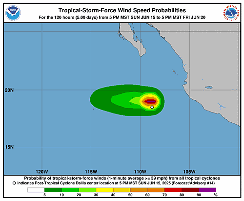
Wind Speed Probabilities last updated Sat, 14 Jun 2025 15:22:29 GMT ]]>


Tropical Sea Temperatures
Visit Weather Underground Tropical Weather Center